 NOAA
NOAA
2014 Tsunamis
• M8.2 Earthquake Generates Local Tsunami In Northern Chile, 01 April 2014
• Two Earthquakes Cause Local Tsunamis In Solomon Islands, 12-13 April 2014
Two Earthquakes Cause Local Tsunamis In Solomon Islands, 12-13 April 2014
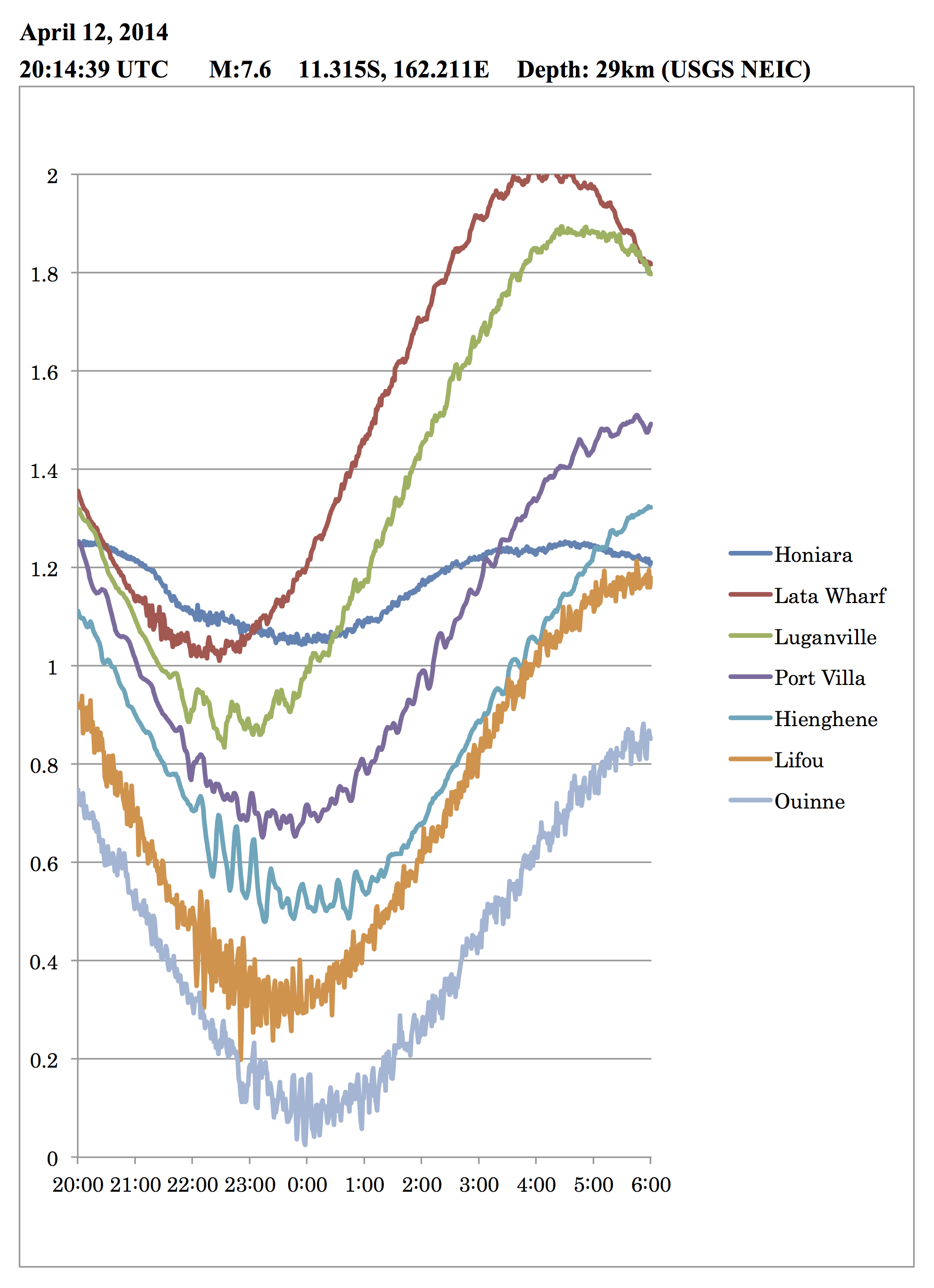
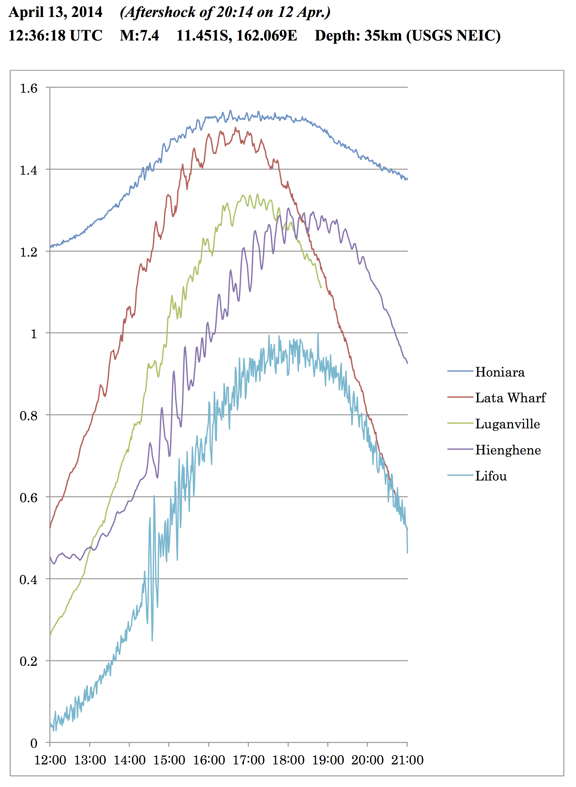
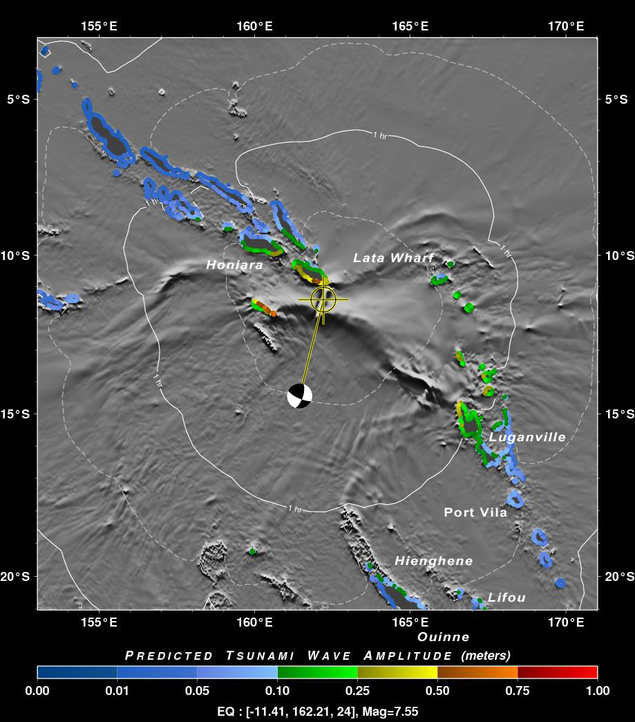
The 12 April 2014 magnitude 7.6 (11.315°S, 162.211°E, depth=29 km, strike-slip faulting) and 13 April 2014 magnitude 7.4 (11.451°S, 162.069°E, depth=35 km, thrust faulting) about 100 km southeast of Kirakira, Solomon Islands generated small, non-destructive local tsunamis. This region is characterized transitional transform tectonics from thrust faulting along New Britain Trench to the northwest to thrust faulting along the New Hebrides Trench to the southeast. The events triggered regional tsunami warning alerts by the PTWC, which cancelled their alerts 1-2 hrs later when only 20-30 cm wave were observed at the Honiara sea level gauge.
| Tsunamis recorded on nearby coastal sea level gauges in the Solomon Islands (Honiara, Lata Wharf), Vanuatu (Luganville, Port Vila), and New Caledonia (Hienghene, Lifou, Ouinne). Courtesy M. Yamamoto. | |
 |
 |
|
|
PTWC RIFT coastal tsunami forecast available ~30 min after the earthquake. |
01 April 2014 (UTC), Mw 8.2, Northern Chile Tsunami
The 1 April 2014 magnitude 8.2 Mw Northern Chile earthquake (19.642 S, 70.817 W, depth 20 km) occurred at 2347 UTC and generated a tsunami that was observed all over the Pacific region and caused damage locally. According to news reports, there were at least 7 dead due to the earthquake ground shaking and over 200 injured. There was tsunami port damage reported at the nearest city of Iquique, Chile, 79 km away from the epicenter and inundation along the coasts of Pisagua and Arica. In February 2010, a magnitude 8.8 Mw located near the central coast of Chile generated a tsunami that caused 156 fatalities.
According to the USGS, the 1 April 2014 earthquake off the Chilean coast occurred as a result of shallow depth thrust faulting slip on the primary plate boundary interface between the Nazca and South American plates. In the region of the earthquake, the Nazca plate subducts eastward beneath the South American plate at a rate of 65 mm/yr.
M8.2 Earthquake Generates Local Tsunami In Northern Chile, 01 April 2014
The 1 April 2014 magnitude 8.2 Mw Northern Chile earthquake (19.642 S, 70.817 W, depth 20 km) occurred at 2347 UTC and generated a tsunami that was observed all over the Pacific region and caused damage locally. According to news reports, there were at least 7 dead due to the earthquake ground shaking and over 200 injured. There was tsunami port damage reported at the nearest city of Iquique, Chile, 79 km away from the epicenter and inundation along the coasts of Pisagua and Arica. In February 2010, a magnitude 8.8 Mw located near the central coast of Chile generated a tsunami that caused 156 fatalities.
According to the USGS, the 1 April 2014 earthquake off the Chilean coast occurred as a result of shallow depth thrust faulting slip on the primary plate boundary interface between the Nazca and South American plates. In the region of the earthquake, the Nazca plate subducts eastward beneath the South American plate at a rate of 65 mm/yr.
For more technical information, visit this tsunami's event page (click here).
PTWC RIFT tsunami forecast animation showing tsunami waves as they propagate across the Pacific.

![]()

Quick Links
![]()
![]()
![]()
Resources


Tsunami Awareness Poster
Available in English, Spanish, Chinese, French, Japanese, Korean, Portuguese, Singalese.

Global & Regional Hazard Maps
Tsunami Sources, Significant Earthquakes, Significant Volcanic Eruptions, Tsunami Icosohedron Globe.


TsunamiTeacher USA
Tsunami Basics
Also on YouTube
(w/closed captioning)
Learn the basics of tsunamis. Available in English, Samoan.