 NOAA
NOAA
2013 Tsunamis
• M8.0 Earthquake Generates Local Tsunami in Santa Cruz Islands, Solomons, 6 February 2013
06 February 2013, Mw 8.0, W of Lata, Solomon Islands Tsunami
The 6 February 2013 magnitude 8.0 Mw Santa Cruz Islands, Solomon Islands earthquake (10.738 S, 165.138 E, depth 29 km) generated a tsunami that was observed all over the Pacific region and caused deaths and damage locally. According to news reports, the worst damage was observed approximately 75 km from the epicenter on the western part of Ndeni (Ndeno) Island where 1.5 meter waves caused 9 deaths, destroyed 460 homes across 5 villages, and damaged the airport at Lata. In 2007, a magnitude 8.1 Mw earthquake located approximately 900 km from this event generated a tsunami that caused 52 deaths.
According to the USGS, the 6 February 2013 earthquake occurred as a result of shallow thrust faulting on or near the plate boundary interface between the Australia and Pacific plates. In the region of this earthquake, the Australia plate converges with and subducts beneath the Pacific plate, moving towards the east-northeast at a rate of approximately 94 mm/yr.
| 1) Alert Information | |
| 2) Sea Level | |
| 3) Seismic | |
| 4) Model Simulations |
|
| 5) Data and Information Sites |
|
| 6) Media |
|
| 7) Photos, Satellite Imagery | |
| 8) Videos | |
| 9) Post-Earthquake Post-Tsunami Surveys |
|
| 10) Other |
|
M8.0 Earthquake Generates Local Tsunami in Santa Cruz Islands, Solomons, 6 February 2013
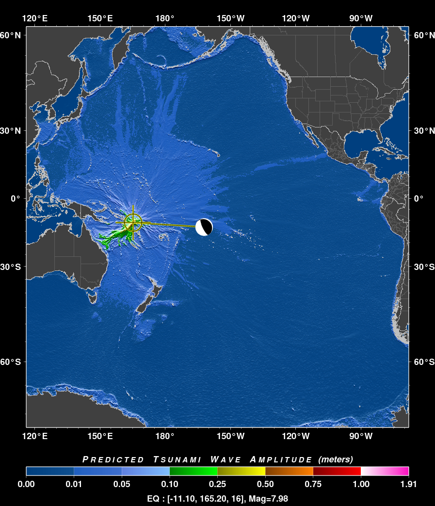
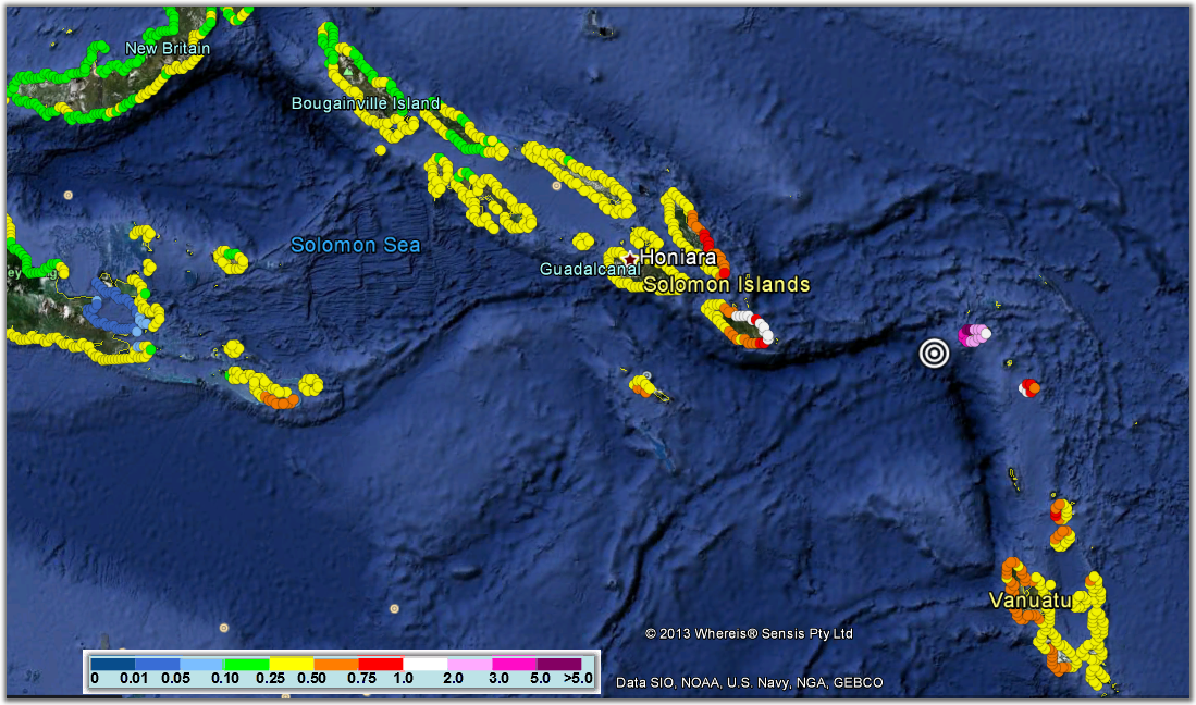
On 6 February 2013, a powerful M8.0 earthquake occurred at 01:12 UTC off the Santa Cruz Islands, Solomons due to shallow thrust faulting at a depth of 28 km on or near the plate boundary interface between the Australia and Pacific plates. The M8 earthquake generated a tsunami that was recorded on sea level gauges around the Pacific. The largest wave of 1 m amplitude was recorded at Lata Wharf located about 50 km from the epicenter. Over the month leading up to the event, there had been dozens of earthquakes in the epicentral region, 7 of which were greater than M6. There were also two greater than M6 aftershocks.
The PTWC issued a regional tsunami warning for countries in the Southwest Pacific 6 minutes after the earthquake and continued to monitor the tsunami. PTWC cancelled the regional warning after 2:32 hours. Reports from the Solomons National Disaster Center indicate at least 9 casualties with damage to at least four villages and about 700 homes in Temoto Province.
 |
|
 |
|
|
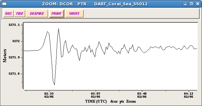
Captions: Right top: A 1 m amplitude tsunami was recorded at Lata Wharf about 50 km from the epicenter. Courtesy of PTWC. Right bottom: DART 55012 deep-ocean instrument in the Coral Sea recorded a 13 cm amplitude tsunami (PTWC). Courtesy of PTWC. |
|
 |
|
|
Above: Detailed RIFT coastal tsunami forecast amplitudes of the Santa Cruz Islands, Solomons magnitude 8.0 earthquake. Courtesy of PTWC. |
|

For more technical information, visit this tsunami's event page (click here).
M8.6 Earthquake Generates Local Tsunami in Indonesia, 11 April 2012
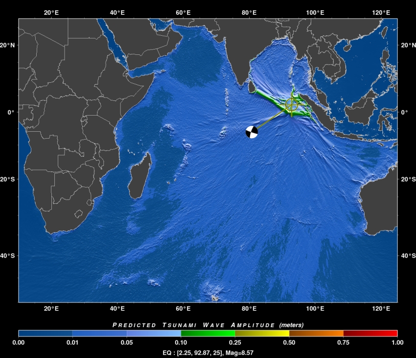
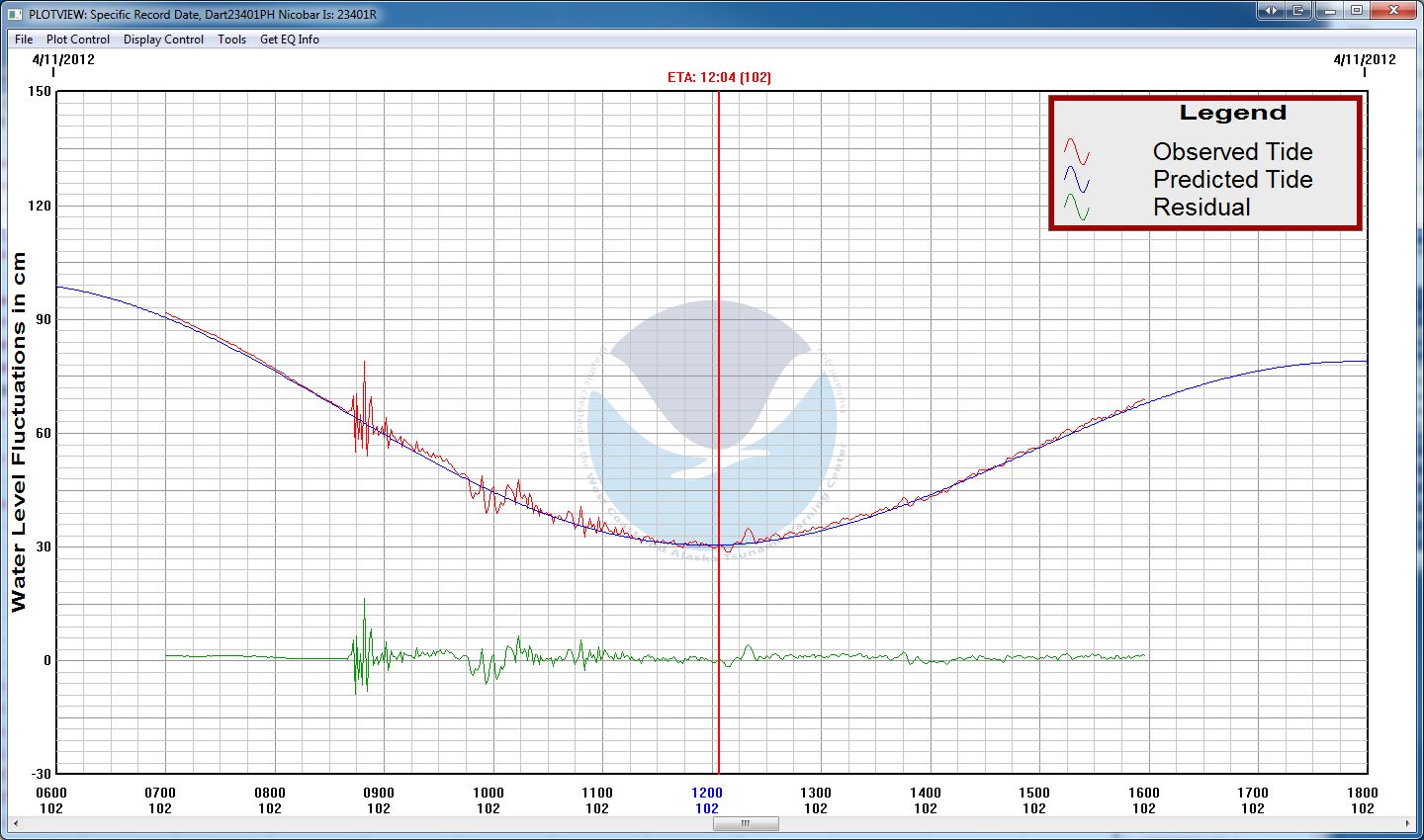
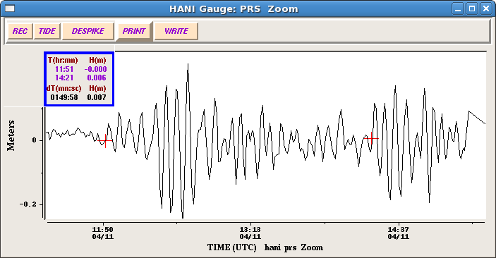
A M8.6 shallow strike-slip earthquake occurred at 0838 UTC 11 April 2012 off the coast of northern Sumatra, Indonesia, and was followed by a second shallow M8.2 strike-slip aftershock at 1043 UTC (USGS). Both generated small local tsunamis with a maximum of 1.06 m measured at 1007 UTC in Meulaboh, Indonesia located about 395 km west southwest of the epicenter. Waves heights up to 0.4 m were recorded throughout the region and as far away as Rodrigues Island, Mauritius in the western Indian Ocean (0.22 m wave amplitude). Amateur video of the tsunami arriving in Indonesia was captured.
Since October 2011, Regional Tsunami Service Providers (RTSP) of Australia, India and Indonesia have been serving as the primary sources for tsunami advisories for the Indian Ocean, with the PTWC and Japan Meteorological Agency (JMA) continuing to operate a parallel service until the end of 2012. The RTSP provide tsunami alerts directly to national tsunami warning centers in each country, and the countries use the advice to assess and issue warnings and advisories to their populations. The PTWC issued an Indian-Ocean wide Tsunami Watch at 0845 UTC, and JMA issued Tsunami Watch Information at 0855 UTC. PTWC cancelled its tsunami watch at 1318 UTC.
Public bulletins are available from the Australia, India, and Indonesia RTSPs, and from the PTWC.
This region of the Indo-Ausralian plate has been seismically very active throughout history, and includes the great M9.1 earthquake of 26 December 2004 that generated the deadliest tsunami ever killing nearly 230,000 in Indonesia and across the Indian Ocean. Immediately following the disaster, the IOC of UNESCO took the lead in coordinating activities and immediate action to establish an Indian Ocean Tsunami Warning and Mitigation System (IOTWS). The response included the start of an interim Advisory Service in 2005 through the PTWC in Hawaii and the JMA in Tokyo, and in 2011 the start of the permanent RTSPs for the Indian Ocean.
 |
|
 |
|
Captions: Left: PTWC RIFT model simulation showing the predicted maximum off-shore tsunami wave amplitudes from the 0838 MTC 11 April 2012 strike-slip earthquake. Right top: Tsunamis recorded on the Hanimaadhoo, Maldives coastal sea level gauge (PTWC). The 1st tsunami (0.23 m amplitude) was generated by the M8.6 0838 UTC earthquake and the 2nd tsunami (0.18 m amplitude) was generated by the M8.2 1043 UTC earthquake. Right bottom: DART 23401 deep-ocean instrument in the Bay of Bengal clearly shows the 2 tsunamis (WC/ATWC) |
|

![]()

Quick Links
![]()
![]()
![]()
Resources


Tsunami Awareness Poster
Available in English, Spanish, Chinese, French, Japanese, Korean, Portuguese, Singalese.

Global & Regional Hazard Maps
Tsunami Sources, Significant Earthquakes, Significant Volcanic Eruptions, Tsunami Icosohedron Globe.


TsunamiTeacher USA
Tsunami Basics
Also on YouTube
(w/closed captioning)
Learn the basics of tsunamis. Available in English, Samoan.