 NOAA
NOAA
02 March 2016, Mw 7.8 Southwest of Sumatra, Indonesia Tsunami
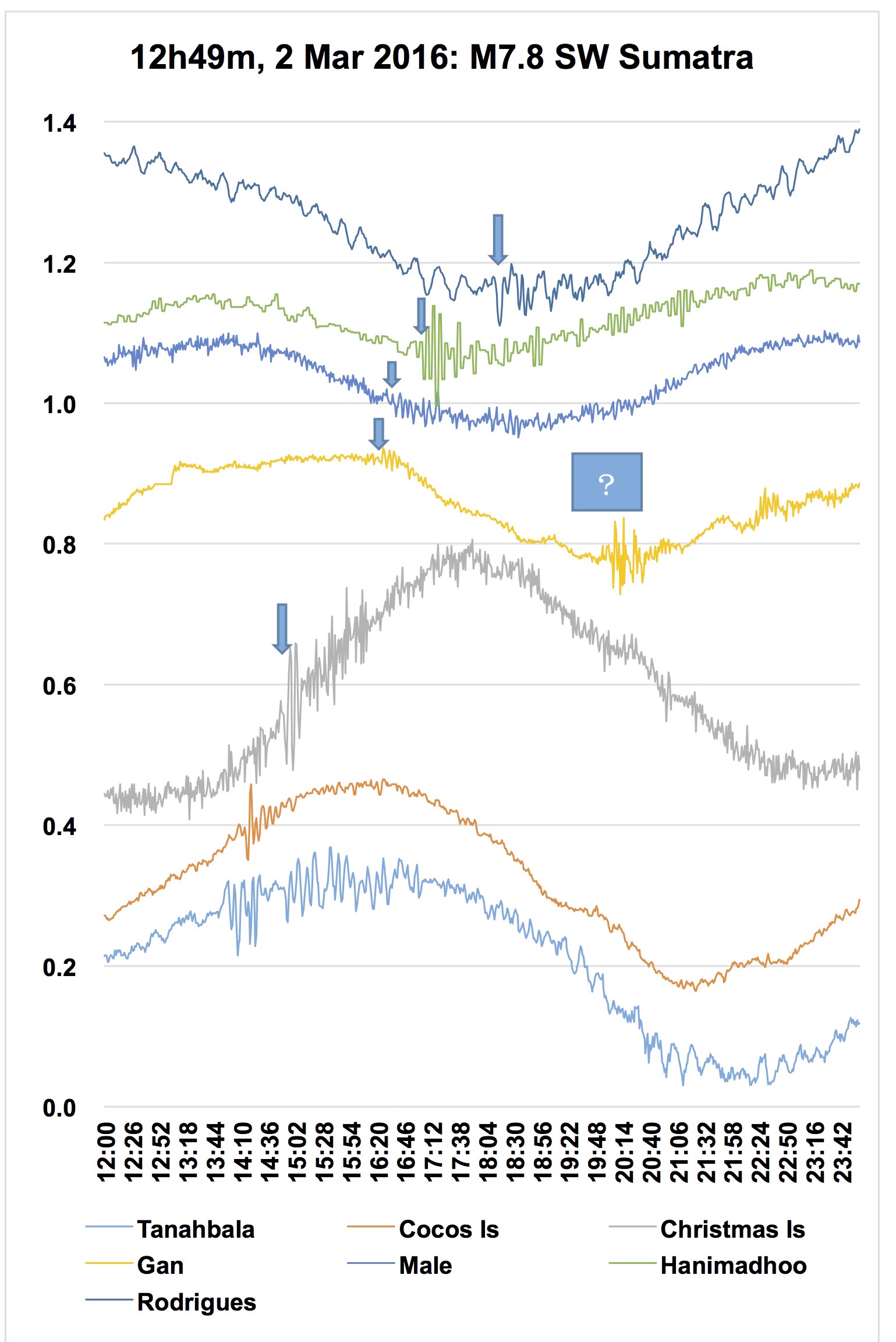
 The M7.8, shallow, Indian Ocean earthquake generated a small tsunami that was recorded on Indian Ocean coastal sea level gauges in Australia (Cocos, Christmas Islands), Indonesia (Tanahbala), Maldives (Gan, Male, Hanimadhoo), and Mauritius (Rodrigues Island). The maximum wave amplitude was 12 cm at Tanahbala.
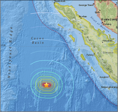
The USGS reported the earthquake occurred at 12:49 UTC, 4.908 °S 94.275 °E, with a depth of 24.0 km (14.9 mi), roughly in the center of the Cocos Basin, and 600 km southwest of the Sunda-Java Trench off Sumatra, northern Indonesia. This intraplate earthquake had a strike-slip faulting mechanism, which rarely generates dangerous tsunamis (see PTWC RIFT forecast below). In contrast, shallow thrust faulting in subduction zones can cause destructive tsunamis, such as the M9.1 2004 Sumatra earthquake that generated 40-m tsunami runups locally, and propagated across the Indian Ocean killing 228,000 in 15 countries.
 Public exchange bulletins were issued by the UNESCO IOC Indian Ocean Tsunami Service Providers (TSP) in India (12:56 – 15:23 UTC, 3 bulletins), and Indonesia (13:19 – 15:53 UTC, 4 bulletins). TSP Exchange bulletins to IOTWMS National Tsunami Warning Centers (NTWC) were issued by Australia (13:06 – 16:57, 7 bulletins), India (12:55 – 15:17, 3 bulletins), and Indonesia (12:49 - 15:53, 4 bulletins).
In April 2013, Australia, India and Indonesia assumed responsibility as the official TSPs for the Indian Ocean. Interim services were provided by the PTWC and JMA from 2005-2013. The TSPs provide tsunami alerts directly to country NTWCs, and each country uses the advice to assess and issue warnings and advisories to their populations. Public bulletins are currently available from the India and Indonesia TSPs.
Indonesia’s National Tsunami Warning Center (BMKG InaTEWS) issued its first bulletin in less than 5 minutes, the second bulletin in less than 10 minutes, and the fourth bulletin (ending of its national tsunami warning) after about 2 hour 40 minutes. Based on television reports, the UNESCO’s Indian Ocean Tsunami Information Center indicated that while there was confusion and panic in the community, it was better than in 2012. Some issues with the media television broadcast of the warning were noted, and are now being discussed with the National Commission for Broadcasters. Persons in Padang, West Sumatera, Mentawai Island, and Muko muko-Bengkulu evacuated, some self-evacuating, and many waiting for the local BMKG in Padang for clarification. Television reported some persons went to the beach to monitor the receding seawater. Unconfirmed reports indicate that a siren was triggered on Mentawai Island after people self-evacuated.
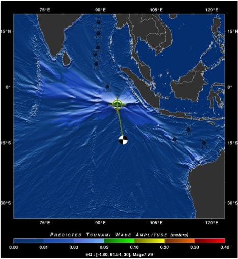
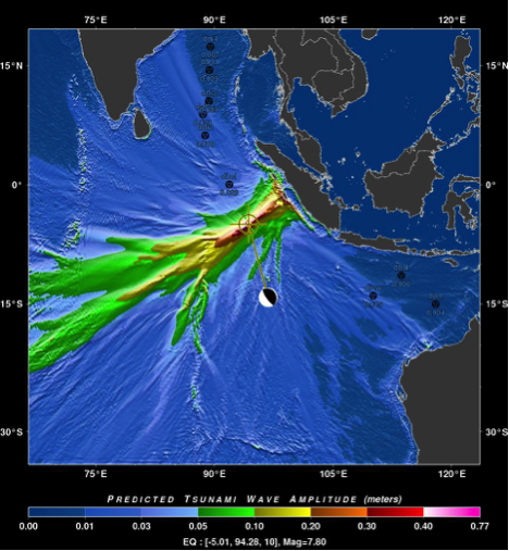
PTWC RIFT model forecasts (deep-ocean tsunami wave amplitudes) showing the direction of greatest tsunami energy (reds and yellows). Depending on the mechanism, significantly different tsunami forecasts are computed. Left: Small waves are forecast, requiring no tsunami warning, using the actual 02 March 2016 W-phase CMT earthquake solution (strike-slip fault mechanism). Right: Large waves, requiring a tsunami warning, would be forecast if a thrust fault mechanism was assumed. (Credit: PTWC)
In 11 April 2012, two large (M8.6, M8.2) strike-slip earthquakes generated small Indian Ocean tsunamis reported in Indonesia, Australia, Sri Lanka, and Thailand, with measurements of up to 1.1 m in Indonesia 395 km west of the epicenter; the M8.6 earthquake was the largest strike-slip event ever recorded. The 2012 earthquakes occurred just north of the 02 March 2016 event.

![]()

Quick Links
![]()
![]()
![]()
Resources


Tsunami Awareness Poster
Available in English, Spanish, Chinese, French, Japanese, Korean, Portuguese, Singalese.

Global & Regional Hazard Maps
Tsunami Sources, Significant Earthquakes, Significant Volcanic Eruptions, Tsunami Icosohedron Globe.


TsunamiTeacher USA
Tsunami Basics
Also on YouTube
(w/closed captioning)
Learn the basics of tsunamis. Available in English, Samoan.