 NOAA
NOAA
6 February 2023, Mw 7.8, Kahramanmaraş, Turkey Tsunami
Kahramanmaras Earthquake Sequence & Tsunami, February 6, 2023
Click here to download the Event Article (PDF, 6.6 MB)
Mw 7.8 Pazarcik earthquake
01:17:34 UTC (04:17 local time)
37.226°N 37.014°E
10.0 km depth
Mw 7.5 Elbistan earthquake
2023-02-06 10:24:48 UTC
38.011°N 37.196°E
7.4 km depth
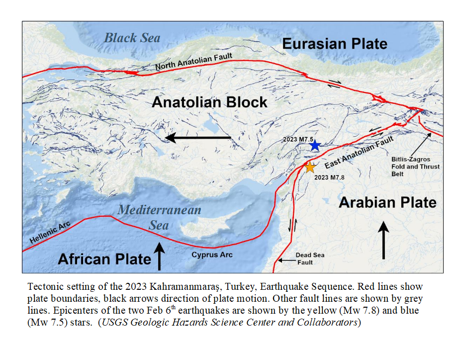
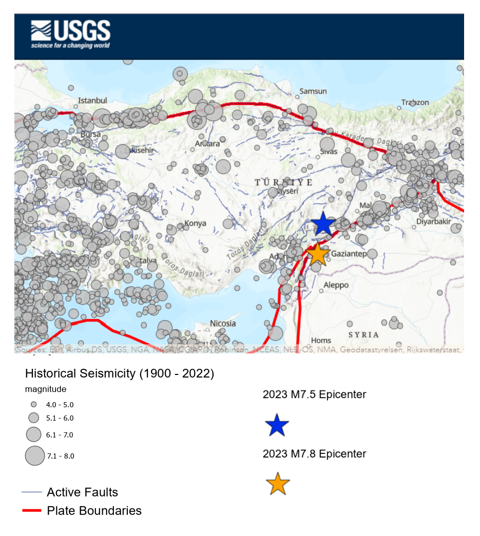
occurred where the Dead Sea Fault between the African and Arabian plates transitions to the East Anatolian Fault between the Arabian plate and Anatolian block. Now known as the Kahramanmaraş Earthquake Sequence, it ruptured about 350 km of the Dead Sea and East Anatolian fault lines. The Mw 7.5 earthquake on the Sürgü fault segment just to the north was likely triggered by stress changes in the crust due to the earlier earthquake and aftershocks; it ruptured over a distance of 100 km.
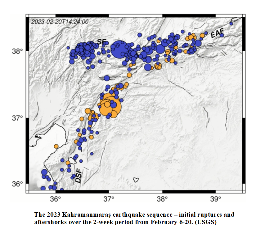
View a USGS animation of the 2023 Kahramanmaraş earthquake sequence (initial ruptures and aftershocks) over the 2-week period from February 6-20:
https://cdn.arcgis.com/sharing/rest/content/items/355bfc8b3c5941e683d4f258e8fb2dfa/resources/
ad2HxSnG_jgE4eT2l9Qn4.mp4?token
The combination of two major earthquakes with numerous aftershocks rupturing a large length of fault lines resulted in extensive damage, made worse by the fault system’s location beneath densely populated areas. The death toll in from the earthquake in Turkey and Syria is estimated at approximately 55,000 people, with thousands more injured and over 2.5 million left homeless.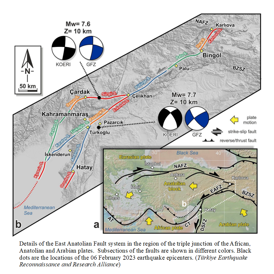
Unlike most earthquakes that cause tsunamis, the Kahramanmaras sequence occurred in an area of transform faults where continental plates are moving alongside each other, rather than in a subduction zone. Subduction zone earthquakes occur where a dense oceanic plate is descending beneath another plate, often under hundreds to thousands of meters of seawater. Common around the Pacific’s “Ring of Fire” and other oceanic basins with high seismic and volcanic activity, they can cause enormous tsunamis.
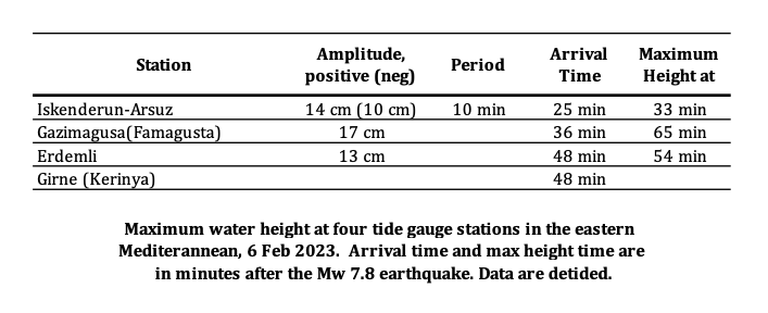
Despite being 90 km from the ocean on a transform fault, the Mw 7.8 earthquake did result in a tsunami. Water height was measured at four tide gauge stations in the Eastern Mediterranean after the earthquake. At Iskenderun, on the far southeast coast of Turkey, the first wave arrived 25 minutes after the earthquake, with a maximum wave height of 14 cm arriving at 8 minutes later. The largest wave height was 17 cm, recorded at Gazimagusa on the island of Cypress.
As a Tsunami Service Provider in the UNESCO IOC Tsunami Warning System, Boğaziçi University’s Kandilli Observatory and Earthquake Research Institute (KOERI) issued four tsunami messages according to the decision matrix based on earthquake magnitude and location. A tsunami warning was issued15 min after the earthquake with expected tsunami amplitudes above 0.5 m along the southern coast of Turkey.
The Türkiye Earthquake Reconnaissance and Research Alliance reported that field surveys were performed on 11-13 February 2023 to investigate the tsunami traces, conduct eyewitness interviews, identify the types and locations of the possible sources, and investigate the damage to the coastal structures. The field surveys covered the coast of the Gulf of Iskenderun from Karatas (West) to Samandag-Cevlik (East).
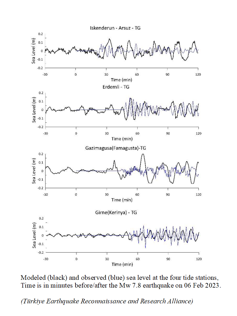
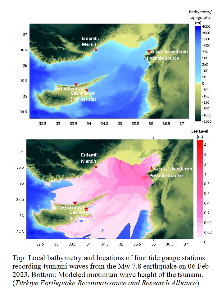
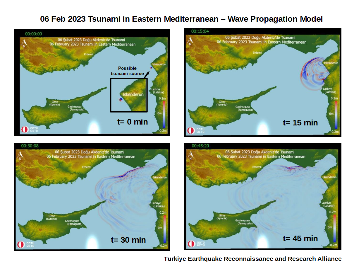
Simulations were performed using the survey findings and the numerical tsunami model NAMI DANCE on a 100 m resolution grid covering the Eastern Mediterranean, and the numerical results were then compared with the tide gauge measurements. Model results show the maximum wave height within the 120-minute simulation time frame, and a time series of sea level as the wave propagates across the eastern Mediterranean.
The arrival times of the waves at the four tide gauges indicate a possible tsunami origin south of Kale cape, southeast of the entrance to Iskenderun Bay. The source appears to have a bipolar elliptical subsidence and uplift shape (see inset on wave propagation figure). It is possible the tsunami was the result of non-seismic mass movement, such as from an underwater landslide triggered by the earthquake, but more data and analysis are needed to confirm or refute the hypothesis.
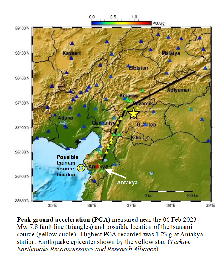
Although the earthquake epicenter was nearly 100 km from the nearest coast, the rupture of the Dead Sea Fault extended far south alongside Iskenderun Bay. A network of 280 strong-motion accelerometers captured peak ground acceleration (PGA) from the Mw 7.8 earthquake over approximately 400 km. The maximum PGA recorded, 1.23 g, was at the Antakya station, just 20 km from the coast adjacent to the probable tsunami source location.
No damage or casualties were reported from the tsunami, although considerable inundation was present near the Iskenderun Fishery port. However, officials reported that “the observations and evidence obtained during the field survey clearly identified that the reason was the subsidence of the coastal area behind the fishery port during the earthquake shaking, most probably due to liquefaction or similar means.” Further exacerbation of the situation occurred from high tides during the full moon when “seawater gradually invaded the subsided area and could not be drained because of collapsed surface water drainage system.”
References and Additional Information
Reconnaissance Report on February 6, 2023 Kahramanmaraş-Pazarcık and Elbistan Earthquakes Türkiye Earthquake Reconnaissance and Research Alliance
https://eerc.metu.edu.tr/en/eerc-reports
The 2023 Kahramanmaraş, Turkey, Earthquake Sequence
USGS Geologic Hazards Science Center and Collaborators
https://earthquake.usgs.gov/storymap/index-turkey2023.html
Disaster Information: Türkiye/Syria Earthquakes UN Office for the Coordination of Humanitarian Affairs (OCHA) https://reliefweb.int/disaster/eq-2023-000015-tur

![]()

Quick Links
![]()
![]()
![]()
Resources


Tsunami Awareness Poster
Available in English, Spanish, Chinese, French, Japanese, Korean, Portuguese, Singalese.

Global & Regional Hazard Maps
Tsunami Sources, Significant Earthquakes, Significant Volcanic Eruptions, Tsunami Icosohedron Globe.


TsunamiTeacher USA
Tsunami Basics
Also on YouTube
(w/closed captioning)
Learn the basics of tsunamis. Available in English, Samoan.