 NOAA
NOAA
Exercise Pacific Wave 11
Historical Tsunami & Seismicity Maps
Regional historical earthquake seismicity and tsunami maps for Exercise Pacific Wave 11, 13, 15, 16, 17, and 18 scenarios.
Maps and data from the US Geological Survey (World Data Center - Seismology, through 2013), and the US NOAA National Geophysical Data Center (World Data Center - Marine Geology and Geophysics/Tsunamis, through 2016).
Further event details can be found by visiting their web sites:
- USGS (https://www.usgs.gov/science-explorer-results?es=world+earthquake+data+center)
- NCEI, formerly NGDC (http://www.ngdc.noaa.gov/hazard/)
Historical Tsunami, Earthquake, and Volcanic Eruption Database (GoogleEarth kmz file, requires internet to view)
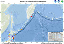
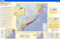
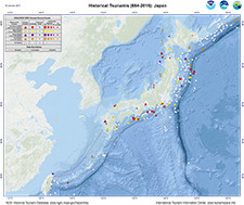
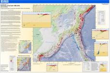
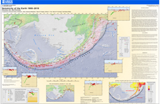
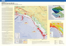
Northwest Pacific (Kuril-Kamchatka Trench, Japan Trench, Nansei-Shoto Trench)
|
Historical Tsunamis Kuril-Kamchatka |
Historical Seismicity Kuril-Kamchatka |
||
|
Historical Tsunamis Japan (PDF, 596 KB) |
Historical Seismicity Japan (PDF, 19 MB) |
||
|
These maps cover the scenarios Kamchatka (Kuril-Kamchatka Trench), Japan (Japan Trench), and Ryukyu Islands (Nansei-Shoto Trench). |
|||
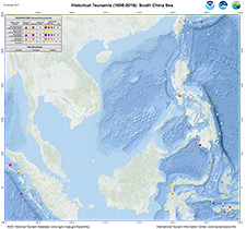
Western Pacific, South China Sea (Manila Trench – Philippines Trench)
|
Historical Tsunamis Western Pacific |
Historical Seismicity Western Pacific |
|
These maps cover the scenarios around the Philippines, South China Sea (Manila Trench) and Pacific Ocean (Philippines Trench) |
|
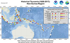
Western Pacific, New Guinea, Solomon Islands region (New Britain, San Cristobal, South Solomon Trenches)
|
Historical Tsunamis New Guinea, Solomon Islands (PDF, 279 KB) |
Historical Seismicity New Guinea, Solomon Islands (PDF, 3 MB) |
| These maps cover the scenarios around New Guinea and the Solomon Islands (New Britain, San Cristobal, South Solomon Trenches) | |
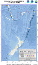
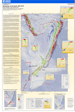
Southwest Pacific (New Hebrides, Tonga Trenches)
|
Historical Tsunamis Southwest Pacific |
Historical Seismicity Southwest Pacific |
|
These maps cover the scenarios near Vanuatu (New Hebrides Trench) and Tonga (Tonga Trench). |
|
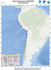
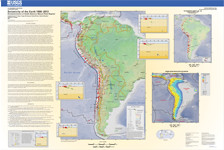
South America (Chile-Peru, Colombia-Ecuador Trenches)
|
Historical Tsunamis South America |
Historical Seismicity South America |
| These maps cover the scenarios Central Chile (Peru-Chile Trench) and Ecuador (Colombia – Ecuador Trench). | |
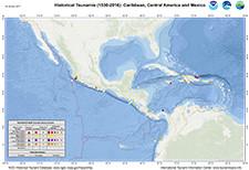
Central America (Middle America Trench)
|
|
|
|
| These maps cover the scenario Central America (Middle America Trench). | ||
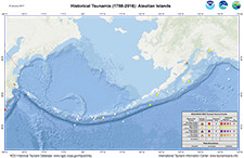
Aleutian Islands (Aleutian Trench)
|
Historical Tsunamis Aleutians (PDF, 430 KB) |
Historical Seismicity Aleutians (PDF, 16 MB) |
| These maps cover the scenario Aleutian Islands (Aleutian Trench). | |
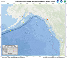
|
Historical Tsunamis SE Alaska, BC Canada |
|
| These maps cover the scenario Southeastern Alaska and British Colombia, Canada (Aleutian Trench). | |

![]()

Quick Links
![]()
![]()
![]()
Resources


Tsunami Awareness Poster
Available in English, Spanish, Chinese, French, Japanese, Korean, Portuguese, Singalese.

Global & Regional Hazard Maps
Tsunami Sources, Significant Earthquakes, Significant Volcanic Eruptions, Tsunami Icosohedron Globe.


TsunamiTeacher USA
Tsunami Basics
Also on YouTube
(w/closed captioning)
Learn the basics of tsunamis. Available in English, Samoan.