 NOAA
NOAA
11 October 1918
Underwater Investigation Reveals Root Cause of the 1918 Puerto Rico Tsunami
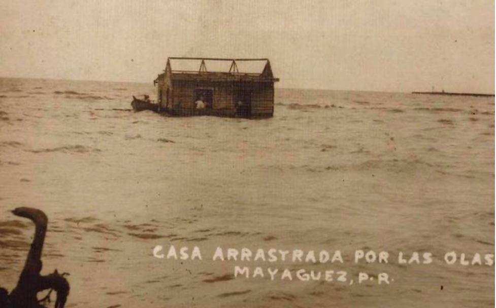
The tsunami washed away a few homes along the western coast of Puerto Rico.
Image reference: BBC News Mundo https://www.bbc.com/mundo/noticias-45793382
On October 11, 1918, the northwestern coast of Puerto Rico bore witness to a seismic event of immense proportions—an earthquake with an estimated magnitude of 7.2. This destructive force triggered a tsunami, unleashing waves as high as 20 feet (6 meters) that battered the island's shores. The tsunami wrought havoc, damaging undersea cables and causing a staggering $4 million in losses, a substantial sum in 1918 currency. This calamity claimed the lives of 116 people, with 40 fatalities attributed to the ensuing tsunami. Yet, lingering doubt persisted for years about whether the earthquake alone was solely responsible for the tsunami's devastation. In 2008, a pivotal study, utilizing boat-mounted multibeam bathymetry, unveiled an underwater landslide deposit at the same location where submarine cables were reported damaged during the 1918 disaster. This discovery led scientists to theorize that the submarine landslide had potentially triggered the tsunami.
However, a recent breakthrough by a dedicated team of researchers has challenged this longstanding theory, providing evidence that the underwater landslide implicated in the 1918 tsunami was far too ancient to be the culprit. Instead, they have identified a nearby fault as the likely instigator of the devastating tsunami, as detailed in their newly published study in the Bulletin of the Seismological Society of America.
Submersible Insight
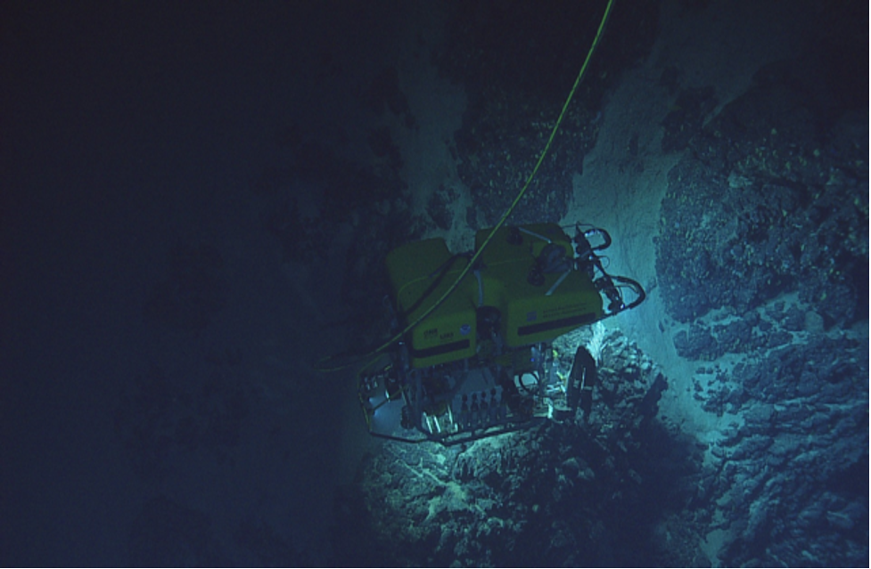 Using an ROV off Puerto Rico's coast, scientists discovered that the age of a landslide
scar disproved it as the 1918 tsunami source. Credit: Ocean Exploration Trust.
Photo credits: Phys.org https://phys.org/news/2023-01-seafloor-video-landslide-source-puerto.html
On October 11, 1918, the northwestern coast of Puerto Rico bore witness to a seismic event of immense proportions—an earthquake with an estimated magnitude of 7.2. This destructive force triggered a tsunami, unleashing waves as high as 20 feet (6 meters) that battered the island's shores. The tsunami wrought havoc, damaging undersea cables and causing a staggering $4 million in losses, a substantial sum in 1918 currency. This calamity claimed the lives of 116 people, with 40 fatalities attributed to the ensuing tsunami. Yet, lingering doubt persisted for years about whether the earthquake alone was solely responsible for the tsunami's devastation. In 2008, a pivotal study, utilizing boat-mounted multibeam bathymetry, unveiled an underwater landslide deposit at the same location where submarine cables were reported damaged during the 1918 disaster. This discovery led scientists to theorize that the submarine landslide had potentially triggered the tsunami.
To gain a more profound understanding of the enigmatic landslide, Uri ten Brink, a geophysicist at the U.S. Geological Survey and co-author of the study, along with his colleagues, harnessed the capabilities of a remotely operated vehicle (ROV) generously provided by the nonprofit Ocean Exploration Trust. This invaluable ROV footage allowed the researchers to scrutinize the surface of the landslide in a stunning three-dimensional vista, offering a level of detail that far surpassed previous boat-mounted bathymetry.
Leveraging specialized software, the research team embarked on an intricate analysis of the ROV footage, meticulously examining each frame to construct a sophisticated 3-D model of the landslide's surface. Upon close inspection of the images, ten Brink and his team made a startling revelation—the landslide was adorned with a ferromanganese crust, a resilient mineral coating that requires hundreds, if not thousands, of years to develop. This astonishing finding cast substantial doubt on the conventional wisdom that this ancient landslide had triggered the 1918 tsunami.
The researchers bolstered their case by extracting sediment samples from the landslide scar using the ROV's arm. Radiocarbon dating of these sediments yielded an age approximately 440 years prior to the present day, far predating the tsunami by over four centuries. This decisive evidence definitively debunked the notion that the landslide could have been responsible for the tsunami.
Unmasking the True Perpetrator
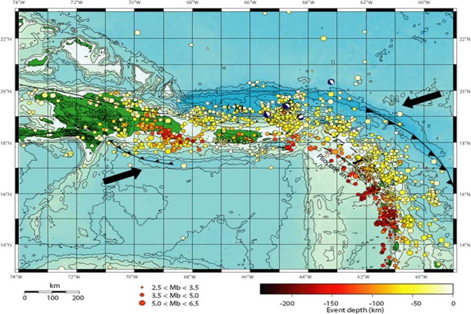 This map illustrates tectonic and seismic activity in the Puerto Rico Trench area,
with arrows indicating the direction of plate movements. Source: USGS.
"Puerto Rico's tectonics are extraordinarily intricate," remarks Noel Bartlow, a geology professor at the University of Kansas who was not involved in the study. She underscores that the region "is likely susceptible to both tectonically-induced tsunamis and landslides-triggered tsunamis." This complex geological landscape added a layer of complexity to the investigation.
The researchers zeroed in on a neighboring fault situated in the Mona Rift region off Puerto Rico's northwestern coast. This fault had previously undergone scrutiny, and a variety of data sources, including bathymetric surveys, seismic data, and historical records of the 1918 earthquake and its aftershocks, hinted at its plausibility as the quake's source. The characteristics of the original earthquake, including its two distinct segments—a moment of intense shaking followed by a less intense event two minutes later—appeared to align with the fault's attributes.
To gain further insight, ten Brink and his colleagues harnessed bathymetric data, in addition to coastal and near-shore lidar data from the National Oceanic and Atmospheric Administration (NOAA). With these resources, they constructed a model illustrating the potential tsunami resulting from an earthquake on this fault.
The model lent strong support to the notion that a magnitude-7.2 earthquake rupturing two segments along the fault could indeed have generated the 1918 tsunami. Moreover, the researchers spotted "recent vertical slickenslides"—indicative scratches on fault surfaces produced by seismic activity—using the ROV. This tangible evidence bolstered their case.
This harmonious convergence of advanced ROV technology, intricate 3-D modeling, and fundamental geological observations empowered the research team to arrive at conclusions that transcended the limits of underwater modeling alone. Harold Tobin, a seismologist at the University of Washington not involved in the study, lauded their work as an exemplar of "geological sleuthing" and underscored the need for more studies of this nature.
Repercussions Beyond Puerto Rico
The ramifications of this discovery resonate beyond the confines of Puerto Rico's submarine geography. Following the 2008 study that previously linked the submarine slump to the tsunami, researchers in various global locales had published studies associating landslides with tsunamis, raising alarms about the potential for tsunamis in regions prone to landslides.
This new research suggests that "perhaps not all tsunamis attributed to submarine landslides conform to scientists' prior assumptions," suggests Tobin. While one study cannot definitively overturn prior findings, it contributes a vital piece to the broader puzzle.
Though the 1918 tsunami is no longer linked to this specific landslide, it is crucial to recognize that the relationship between tsunamis and landslides remains intact. As Bartlow points out, "The landslide scar is still there," and prior modeling had indicated that it could produce a similar tsunami, just not in 1918.
This study serves as a potent reminder of the iterative and self-correcting nature of scientific inquiry. Scientists continually reevaluate old conclusions in light of new evidence, contributing to the refinement and expansion of our understanding of natural phenomena.
Uri ten Brink, reflecting on the significance of their research, underscores the importance of setting the record straight: "I don't want to say landslide-induced tsunamis won't happen somewhere else, but it's good to 'set the record straight' on what happened at this site."
In conclusion, the saga of the 1918 Puerto Rico tsunami and its subsequent unraveling by a dedicated team of scientists highlights the ever-evolving nature of scientific knowledge. Through innovative technology and rigorous investigation, they have illuminated the true cause of this historic catastrophe while also shedding light on the intricate interplay between geological processes and tsunamis in the depths of the ocean.
Source: https://www.researchgate.net/publication/236904633_Did_a_submarine_slide_trigger
_the_1918_Puerto_Rico_tsunamithe_1918_Puerto_Rico_tsunami
http://prsn.uprm.edu/English/information/quake1918.php

![]()

Quick Links
![]()
![]()
![]()
Resources


Tsunami Awareness Poster
Available in English, Spanish, Chinese, French, Japanese, Korean, Portuguese, Singalese.

Global & Regional Hazard Maps
Tsunami Sources, Significant Earthquakes, Significant Volcanic Eruptions, Tsunami Icosohedron Globe.


TsunamiTeacher USA
Tsunami Basics
Also on YouTube
(w/closed captioning)
Learn the basics of tsunamis. Available in English, Samoan.