 NOAA
NOAA
26 January 1700
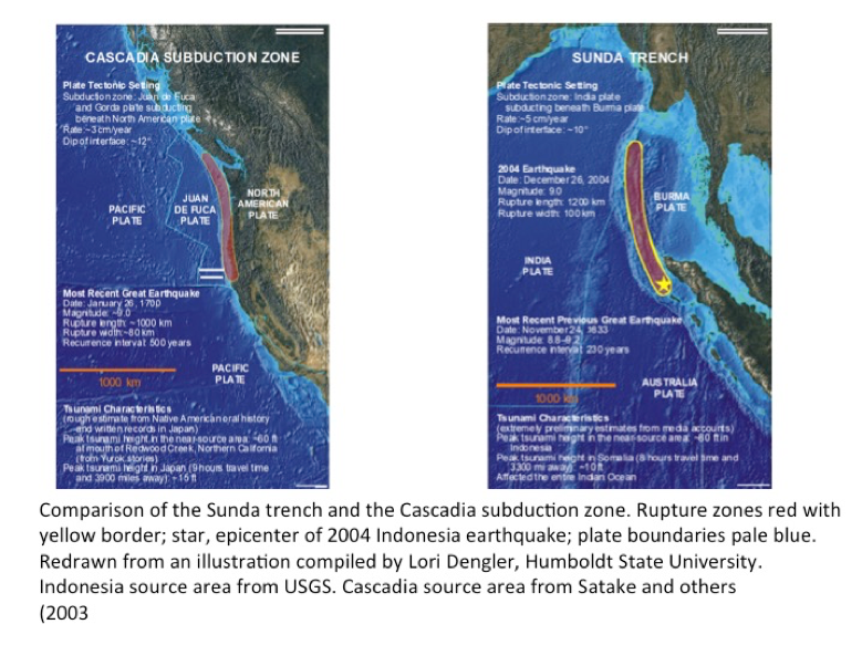
Cascadia subduction zone is the long fault boundary between the North American and Juan de Fuca plates. It produced great-magnitude earthquakes that have generated tsunamis at least six times in the past 3,500 years. It extends 700 miles from Vancouver Island, Canada, to Cape Mendocino, California. In its earthquake and tsunami potential, the CSZ resembles the Sunda Trench that produced a giant earthquake off the coast of Sumatra Island, Indonesia on December 26, 2004.
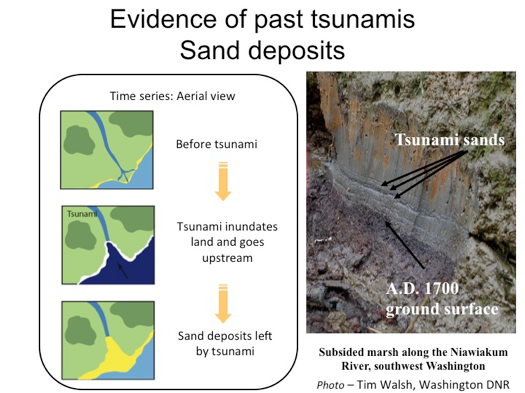
Tsunamis pick up very distinctive sands (sometimes the minerals are different or there are marine microfossils like foraminifera or diatoms - like plankton) as they form, and they deposit those on as they wash over the landscape. At Niawiakum the bottom is forest peat, then tsunami sand, then marine mud).
Sedimentary tsunami deposits allow geologists to expand the record of the tsunamis. For example, frequency and magnitude can be assessed through tsunami deposits. If more than one tsunami deposit is preserved, it is possible to determine tsunami recurrence. Finally, deposits can tell the minimum distance inland and run up as well as the minimum current needed to move the sediment.
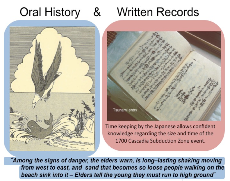
Oral history has been used by many cultures throughout the world to educate and pass information from generation to generation. For example, oral traditions of Native American tribes along the Pacific Coast described what is interpreted as a huge earthquake and tsunami destroying coastal villages. This tradition has been very helpful to complement scientific data.
The accurate written records from samurai, merchants, and villagers of the tsunami and the accurate time keeping by the Japanese that allows confident knowledge of the size and time of the 1700 Cascadia Subduction Zone event.
Japanese written historical records pinpoints a tsunami in Japan as having originated in the Cascadia Subduction Zone on the evening of January 26, 1700. This estimated M 9.0 earthquake produced a tsunami that struck the Pacific Coast and traveled to Japan, damaging coastal communities there. In North America, the earthquake and its tsunami left geological evidence along the Pacific Coast, and captured in Native American oral history as well.

![]()

Quick Links
![]()
![]()
![]()
Resources


Tsunami Awareness Poster
Available in English, Spanish, Chinese, French, Japanese, Korean, Portuguese, Singalese.

Global & Regional Hazard Maps
Tsunami Sources, Significant Earthquakes, Significant Volcanic Eruptions, Tsunami Icosohedron Globe.


TsunamiTeacher USA
Tsunami Basics
Also on YouTube
(w/closed captioning)
Learn the basics of tsunamis. Available in English, Samoan.