 NOAA
NOAA
17 June 2017, Karrat Fjord, Greenland Landslide & Tsunami
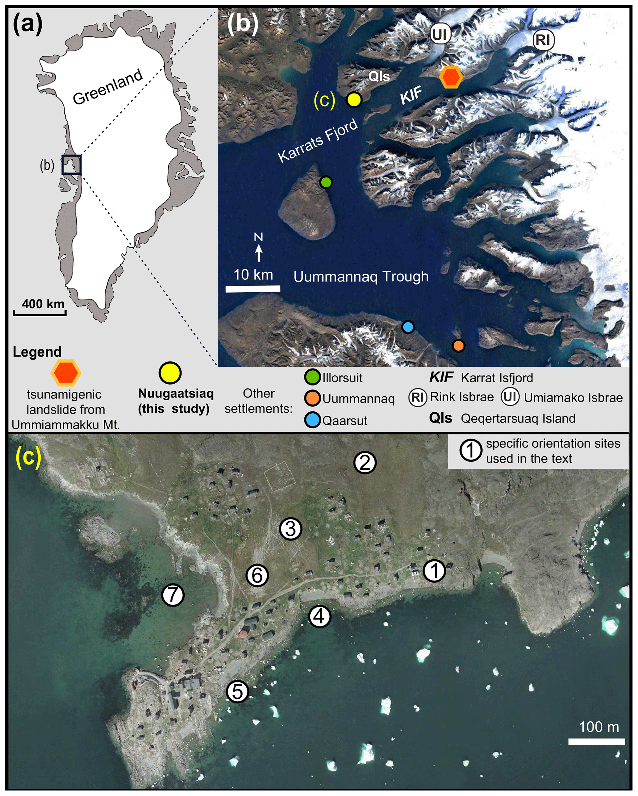 Location of the 17 June 2017 Karrats Fjord landslide and tsunami.
(From Strzelecki and Jaskólski, 2020).
Massive tsunami in Karrat Fjord, Greenland, June 2017
On 17 June 2017, a huge tsunami occurred in the Karrat Fjord on the west coast of Greenland, resulting in severe property damage and casualties in the tiny fishing village of Nuugaatsiaq. The seismic energy detected prior to the tsunami was so large it was first thought to have been the result of a magnitude 4.1 earthquake. However, the cause was a massive landslide on a steep slope of the fjord where millions of cubic meters of rock plunged into the water below, 32 kilometers northeast of the village. Forty-five structures, including eleven houses, were washed away or destroyed, and four people were killed.
Nature | News, July 2017: Huge landslide triggered rare Greenland megatsunami
That disturbance pushed water levels up by more than 90 meters along the coastline on the same side as the landslide. Although the tsunami dissipated quickly as it crossed the deep, six-kilometer-wide fjord, it still had enough energy to send water 50 meters up the opposite hillside. The team also measured an increase in water levels of about 10 meters on shorelines 30 kilometers away.
A series of waves inundated the shoreline settlement") at about 1-minute intervals. Wave heights were 1-2 meters and runup extended to 9 meters above sea level. Among several videos recorded during the event, this one shot from a kitchen window camera shows the progression from the first wave to the sixth and largest (which destroys the house; 5:00-6:09 in video).
at about 1-minute intervals. Wave heights were 1-2 meters and runup extended to 9 meters above sea level. Among several videos recorded during the event, this one shot from a kitchen window camera shows the progression from the first wave to the sixth and largest (which destroys the house; 5:00-6:09 in video).
The extent of the tsunami-triggering landslide was enormous, covering an area 1000 meters by 300 meters, with a minimum mass displacement of 35-51 million cubic meters, most of which fell into the fjord.
The seismic signal was seen by all 30+ instruments in the Greenland Ice Sheet Monitoring Network (GLISN), including the NUUG station. Located at a higher elevation just outside the village, it continued recording until 10 minutes after the event when power was lost. GLISN and USGS analyzed the seismic records which indicated signals that the vertical movement was caused by the landslide itself and not the earthquake.
Initially, the seismic signals had characteristics typical of a large rapid landslide. These characteristics start with a long-period pulse prior to the appearance of the higher frequency energy. Unlike earthquakes where the first P and S wave arrivals can often be seen clearly and picked with relative accuracy for location and magnitude calculations, the higher frequency energy from landslides emerges gradually from the noise and no wave phases are clearly distinguishable. “…We do not see any characteristics in the seismic data, such as clear P and S wave arrivals, to suggest there was a triggering earthquake, so the observed signal is likely completely generated by the landslide and tsunami sequence itself.” (Bessette-Kirton, USGS, 2017)
However, multiple investigations have found signals in the seismic record preceding the massive landslide. For example, Poli (2017) reported that “[a]nalysis of precursors implies that an aseismic slip event is taking place for hours before the landslide, with an exponential increase of slip velocity…” Poli goes on to say,“[t]he pulses occur more frequently with time, until they effectively merge with the seismic signal of the landslide.” (Caplan-Auerbach 2017 AGU). Butler (2019) found 100 significant energy peaks accelerating up to and into the earthquake–landslide event.
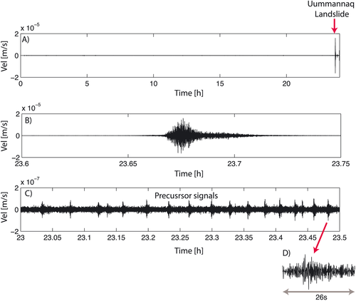 Signals from a nearby seismic station showing the main landslide event (panel B) and precursor signals occurring in the hours before the landslide (panel C). Note 100x smaller scale in the precursor seismograph (10-5 vs 10-7 m/s). From P. Poli (2017)
Landsat satellite imagery also revealed preexisting scarps, tension cracks, and debris fields in the landslide area dating as far back as 2011. This indicates prior landslides and slope instability. Remnants of one landslide 1-2 years prior “…remains perched on the hill slope above the fjord. If the West landslide were to fail catastrophically similar to the June 17 event, it could potentially generate a future tsunami.” (USGS 2017).
In addition to human casualties and destruction of buildings, Strzelecki and Jaskólski (2020) extensively documented many other consequences of the tsunami including environmental degradation (hazardous material leakage, erosion, etc), deaths of sled dogs, and social disruption.
") Residents of Nuugaatsiaq and other villages in the fjord were required to resettle following the tsunami while geological studies were conducted to assess the possibility of additional landslides. Satellite analysis of land movement on the fjord slopes has confirmed instability that could result in more catastrophic failures and destructive tsunamis. Thus in October of 2020, Greenland’s Public Safety Commission extended the closure of Nuugaatsiaq and part of the fjord indefinitely (Article).
Residents of Nuugaatsiaq and other villages in the fjord were required to resettle following the tsunami while geological studies were conducted to assess the possibility of additional landslides. Satellite analysis of land movement on the fjord slopes has confirmed instability that could result in more catastrophic failures and destructive tsunamis. Thus in October of 2020, Greenland’s Public Safety Commission extended the closure of Nuugaatsiaq and part of the fjord indefinitely (Article).
One of the reasons for the abundance of caution is the remoteness of the area, settlements in Greenland in general are often far from the kind of infrastructure needed for the engineering of early warning systems.
Similar glacial/fjord slope collapses have been at least partially attributed to melting of ice and rock-ice mixtures that serve to buttress the steep sides of glacial valleys, but the extent of this mechanism in the Karrat Fjord, if any, is not known. See the ITIC article “Retreating glaciers: Can a warming climate increase tsunami risk?” for more discussion and examples.
References and Additional Reading
Preliminary Analysis of Satellite Imagery and Seismic Observations of the Nuugaatsiaq Landslide and Tsunami, Greenland (Bessette-Kirton et al., USGS, 2017)
GLISN seismic observations (Clinton et al., 2017)
Precursory Seismicity Associated With Landslides, Including the 2017 Tsunamigenic Landslide in the Karrat Fjord, Greenland (Caplan-Auerbach 2017)
Creep and Slip: Seismic precursors to the Nuugaatsiaq landslide (Greenland) (Poli 2017)
Seismic precursors to a 2017 Nuugaatsiaq, Greenland, earthquake–landslide–tsunami event.
(Butler 2019)
Arctic tsunamis threaten coastal landscapes and communities – survey of Karrat Isfjord 2017 tsunami effects in Nuugaatsiaq, western Greenland. (Strzelecki and Jaskólski, 2020)
Retreating glaciers: Can a warming climate increase tsunami risk? (ITIC website)

![]()

Quick Links
![]()
![]()
![]()
Resources


Tsunami Awareness Poster
Available in English, Spanish, Chinese, French, Japanese, Korean, Portuguese, Singalese.

Global & Regional Hazard Maps
Tsunami Sources, Significant Earthquakes, Significant Volcanic Eruptions, Tsunami Icosohedron Globe.


TsunamiTeacher USA
Tsunami Basics
Also on YouTube
(w/closed captioning)
Learn the basics of tsunamis. Available in English, Samoan.